
Magnolia Markers
Mississippi's Historical Marker program
Since 1949 the State Historical Marker program has identified and interpreted the most important historical sites across Mississippi. The familiar silver and green tablets stand in practically every city and town in the state, commemorating significant people, events, or movements. Nearly eight hundred markers can be found near buildings, battlefields, cemeteries, churches, temples, forts, and abandoned towns.
Historical markers serve visitors to the state and residents alike. For tourists the markers may be their only glimpses into the state's rich and varied history. For Mississippi communities the markers can be points of pride that memorialize locally important people and events.
State Historical Markers are privately sponsored and funded. Anyone may sponsor a marker. To qualify, a site must have unique historical significance to the local community, the state, or the nation. Each marker's subject and content must be supported with primary source documentation and approved by the MDAH Board of Trustees, which meets quarterly every year. Visit the MDAH Historical Marker Program page for pricing and request forms.
There are currently 22 State Historical Markers in Hancock County.
Magnolia Markers in Hancock County
Old Shieldsboro
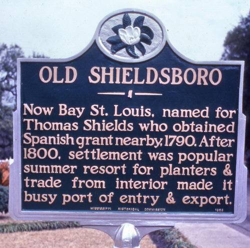
Now Bay St. Louis, named for Thomas Shields who obtained Spanish grant nearby 1790. After 1800, settlement was popular summer resort for planters & trade from interior made it busy port of entry & export.
Location: in front of old City Hall on 300 Second Street, Bay Saint Louis (although the marker was originally located on Hwy 90 near the Bay Bridge).
Date: 1958. Rededicated on October 22, 1981
Hancock County Bank
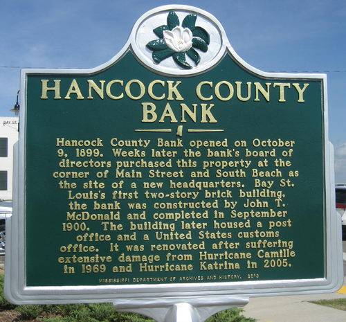
Hancock County Bank opened on October 9, 1899. Weeks later the bank's board of directors purchased this property at the corner of Main Street and South Beach as the site of a new headquarters. Bay St. Louis's first two-story brick building, the bank was constructed by John T. McDonald and completed in September 1900. The building later housed a post office and a United States customs office. It was renovated after suffering extensive damage from Hurricane Camille in 1969 and Hurricane Katrina in 2005.
Location: in front of the bank at the corner of Main Street and Beach Boulevard, Bay Saint Louis.
Date: 2013
Bay St. Louis Depot

Designated as a Mississippi Landmark and listed in the National Register of Historic Places, this rail depot was built by the L&N Railroad circa 1929. The Spanish Colonial style building was purchased by the city of Bay St. Louis in 1994 and restored in 1996.
Location: 1 Depot Way, between Railroad and Blaize Avenue, Bay Saint Louis. (Marker destroyed in Katrina)
Date: Unknown
Bay St. Louis
Organized as Shieldsboro in 1858. Renamed in 1875 for bay explored by Iberville in 1699 on the birthday of Louis IX. Town built on site of Chicapoula, former Indian Village.
Location: West end of bridge on U.S. 90, Bay Saint Louis. (Marker destroyed in Katrina)
Date: Unknown
Elmwood Manor
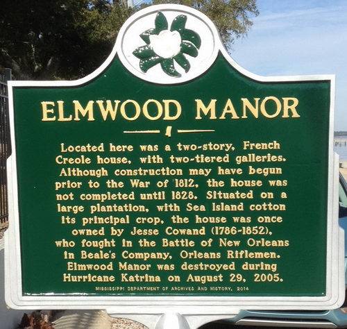
Located here was a two-story, French Creole house, with two-tiered galleries. Although construction may have begun prior to the War of 1812, the house was not completed until 1828. Situated on a large plantation, with Sea Island cotton its principal crop, the house was once owned by Jesse Cowand (1788-1852), who fought in the Battle of New Orleans in Beale's Company, Orleans Riflemen. Elmwood Manor was destroyed during Hurricane Katrina on August 29, 2005.
Location: 900 North Beach Boulevard, Bay Saint Louis.
Date: 2014
Our Lady of the Gulf
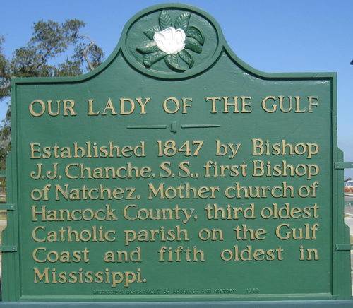
Established 1847 by Bishop J. J. Chanche, S. S., first Bishop of Natchez. Mother church of Hancock County, third oldest Catholic parish on the Gulf Coast and fifth oldest in Mississippi.
Location: 228 South Beach Boulevard, Bay Saint Louis
Date: 1977
Brown’s Vineyard
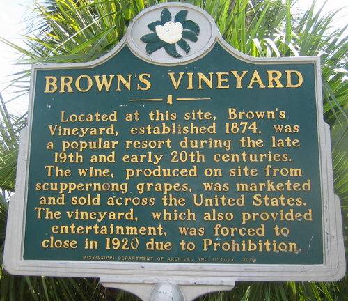
Located at this site, Brown’s Vineyard, established 1874, was a popular resort during the late 19th and early 20th centuries. The wine, produced on site from scuppernong grapes, was marketed and sold across the United States. The vineyard, which also provided entertainment, was forced to close in 1920 due to Prohibition.
Location: Hwy 90 east of Waveland Ave.
Date: 2004
Publius Rutilius Rufus Pray
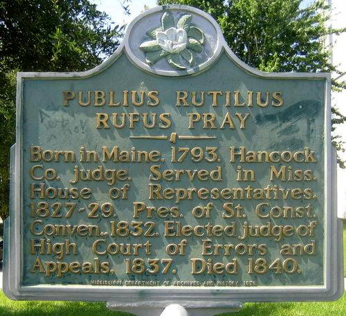
Born in Maine, 1793. Hancock Co. judge. Served in Miss. House of Representatives, 1827-29. Pres. of St. Const. Conven., 1832. Elected judge of High Court of Errors and Appeals, 1837. Dead 1840.
Location: In front of the Hancock County Courthouse, 150 Main Street, Bay Saint Louis
Date: Unknown
Gulf Side Assembly
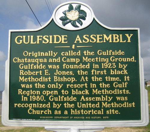
Originally called the Gulfside Chatauqua and Camp Meeting Ground, Gulfside was founded in 1923 by Robert E. Jones, the first black Methodist Bishop. At the time, it was the only resort in the Gulf Region open to black Methodists. In 1980, Gulfside Assembly was recognized by The United Methodist Church as a Historical Site.
Location: 950 South Beach Boulevard, Waveland
Date: Unknown
St. Stanislaus College
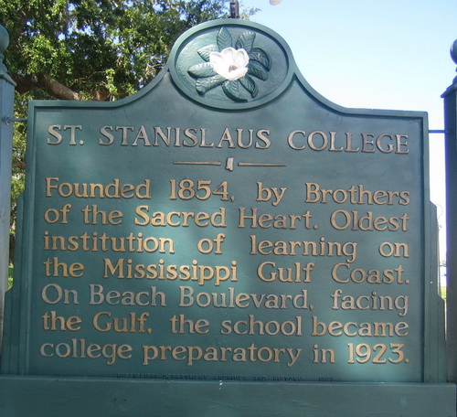
Founded 1854, by Brothers of the Sacred Heart. Oldest institution of learning on the Mississippi Gulf Coast. On Beach Boulevard, facing the Gulf, the school became college preparatory in 1923.
Location: In front of the school, 304 South Beach Boulevard, Bay St. Louis. (Marker destroyed in Katrina but later restored)
Date: 1969
Naval Battle of Bay St. Louis
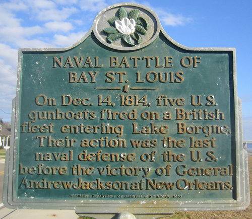
One Dec. 14, 1814, five U.S. gunboats fired on a British fleet entering Lake Borgne. Their action was the last naval defense of the U.S. before the victory of General Andrew Jackson at New Orleans.
Location: On the corner of Ulman Avenue and Beach Boulevard, Bay Saint Louis
Date: Unknown
St. Augustine’s Seminary
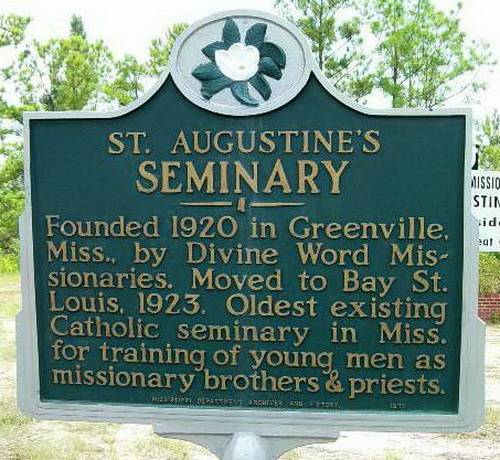
Founded 1920 in Greenville, Miss., by Divine Word Missionaries. Moved to Bay St. Louis, 1923. Oldest existing Catholic seminary in Miss. for training of young men as missionary brothers & priests.
Location: In front of the Seminary on Hwy 90 E, Bay Saint Louis
Date: 1970
Old Spanish Customs House
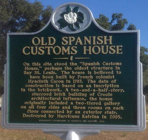
On this site stood the “Spanish Customs House,” perhaps the oldest structure in Bay St. Louis. The house is believed to have been built by French colonist Hyacinth Caron in 1787. The date of construction is based on an inscription in the brickwork. A two-and-a-half-story, stuccoed brick building of Creole architectural influence, the house originally included a two-tiered gallery on all four sides and three rooms on each floor connected by an exterior stair. Destroyed by Hurricane Katrine in 2005.
Location: 708 South Beach Boulevard, Bay Saint Louis.
Date: 2014
The “Pirate House”
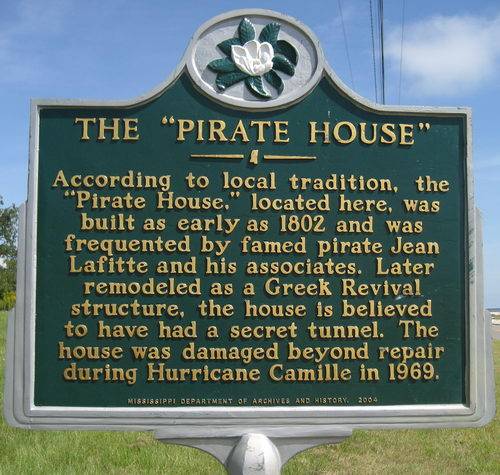
According to local tradition, the “Pirate House”, located here, was built as early as 1802 and was frequented by famed pirate Jean Lafitte and his associates. Later remodeled as a Greek Revival structure, the house is believed to have had a secret tunnel. The house was damaged beyond repair during Hurricane Camille in 1969.
Location: 645 North Beach Boulevard, Waveland.
Date: 2004
Pearl Rivers
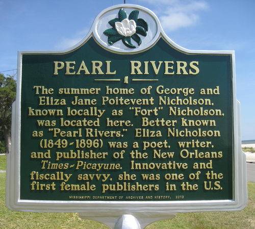
The summer home of George and Eliza Jane Poitevent Nicholson, known locally as "Fort" Nicholson, was located here. Better known as "Pearl Rivers", Eliza Nicholson (1849-1896) was a poet, writer, and publisher of the New Orleans Times-Picayune. Innovative and fiscally savvy, she was one of the first female publishers in the US.
Location: Just north of the intersection of Beach Boulevard and Nicholson Avenue, Waveland
Date: 2013
Sea Song Plantation
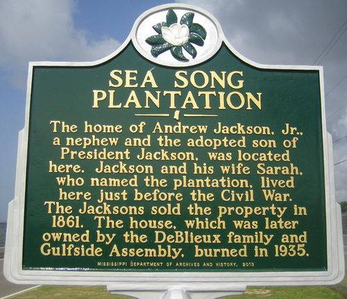
The home of Andrew Jackson, Jr., a nephew and the adopted son of President Jackson, was located here. Jackson and his wife Sarah, who named the plantation, lived here just before the Civil War. The Jacksons sold the property in 1861. The house, which was later owned by de DeBlieux family and Gulfside Assembly, burned in 1935.
Location: Buccaneer State Park, 1150 South Beach Boulevard, Waveland
Date: 2003, replaced in 2013
Gainesville Volunteers
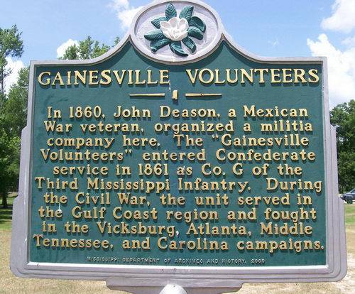
In 1860, John Deason, a Mexican War Veteran, organized a militia company here. The “Gainesville Volunteers” entered Confederate service in 1861 as Co. G. of the Third Mississippi Infantry. During the Civil War the unit served in the Gulf Coast region and fought in the Vicksburg, Atlanta, Middle Tennessee,and Carolina campaigns.
Location: In front of the Mississippi Welcome Center on I-10 at the border with Louisiana.
Date: 2000
John C. Stennis Space Center

In 1961 President John F. Kennedy announced plans to send humans to the moon. NASA selected this site for an engine testing facility for the Apollo Moon program. During its construction in 1963, nearly 6,100 workers began building three 200-foot-tall test stands. This 13,800-acre federal city, the largest rocket engine testing facility un the United States, is surrounded by a 125,000-acre buffer zone. The Stennis Space Center tested the main engines for each of the 135 space shuttle missions.
Location: On Highway 607, south of the Stennis Gate, at the turn to Napoleon
Date: October 25, 2011
First Baptist Church of Bay St. Louis
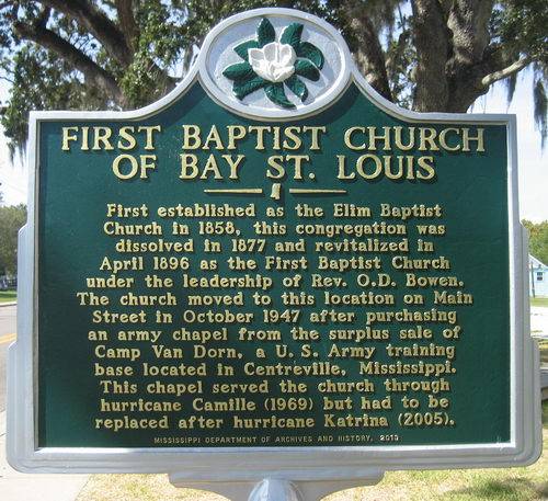
First established as the Elim Baptists Church in 1858, this congregation was dissolved in 1877 and revitalized in April 1896 as the First Baptists Church under the leadership of Rev. O.D. Bowen. The church moved to this location on Main Street in October 1947 after purchasing an army chapel from the surplus sale of Camp Van Dorn, a U.S. Army training base located in Centreville, Mississippi. This chapel served the church through hurricane Camille (1969) but had to be replaced after hurricane Katrina (2005).
Location: In front of the church at 141 Main Street, Bay Saint Louis.
Date: 2013
Pearlington
Colonial Town; chartered 1832. Site of early cotton gin & dry dock. A pioneer in lumbering, it boomed under Poitevent & Favre Co. (1866-1906), one of world’s largest mills.
Location: Intersection of U.S. 90 & State Road 604.
Date: 2013
Logtown

Founded here in 1848, Logtown was home to the Weston Lumber Company, founded in 1889, which became one of the largest lumber milling operations in the United States during the 1920s. By 1961 the last 250 residents were removed to make way for the buffer zone needed for engine testing at the John C. Stennis Space Center for NASA's Apollo Moon Program.
Location: Logtown Cemetery, off State Road 604.
Date: 2013
Santa Rosa
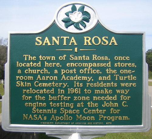
The town of Santa Rosa, once located here, encompassed stores, a church, a post office, the one-room Aaron Academy, and Turtle Skin Cemetery. Its residents were relocated in 1961 to make way for the buffer zone needed for engine testing at the John C. Stennis Space Center for NASA's Apollo Moon Program.
Location: Turtleskin Cemetery, just north of the entrance to Stennis on Highway 607.
Date: 2013
Other interesting markers in Hancock County
100 Men D.B.A. Hall Blues Trail marker

The 100 Men D.B.A. Hall, a longtime center of African American social life and entertainment, was built in 1922 by the One Hundred Member's Debating Benevolent Association. Over the years the association sponsored many events and also rented the hall to promotors who brought in blues, rhythm & blues, and jazz acts. Local residents have recalled performances by Etta James, Big Joe Turner, Guitar Slim, Irma Thomas, Professor Longhair, Ernie K-Doe, Deacon John, Earl King, and numerous others here.
Location: 303 Union Street, Bay Saint Louis
Date: June 17, 2011
Blue Star Memorial
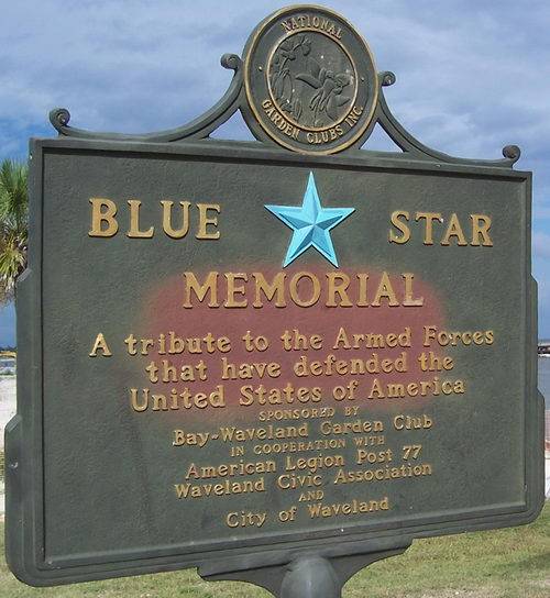
A tribute to the Armed Forces that have defended the United States of America. Sponsored by Bay-Waveland Garden Club in cooperation with American Legion Post 77, Waveland Civic Association and City of Waveland.
Location: South Beach Boulevard and Coleman Avenue, Waveland
Date: Unknown
Napoleon
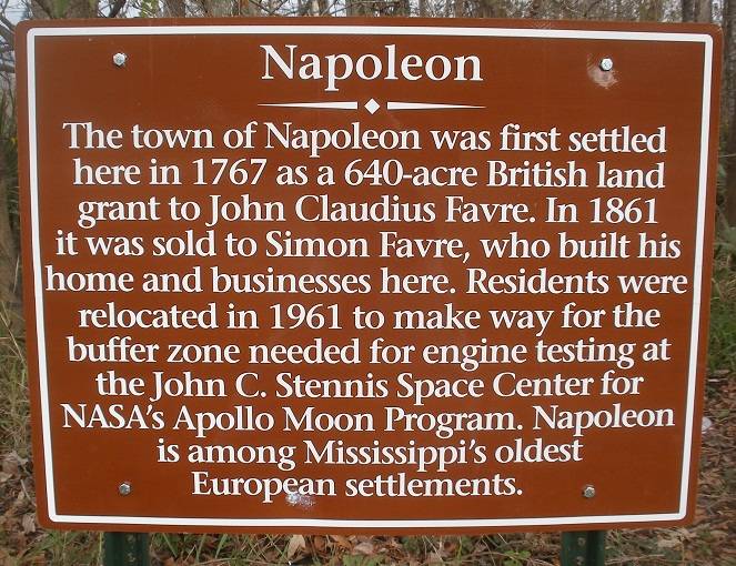
The town of Napoleon was first settled here in 1767 as a 640-acre British land grant to John Claudius Favre. In 1861 it was sold to Simon Favrre, who built his home and businesses here. Residents were relocated in 1961 to make way for the buffer zone needed for engine testing at the John C. Stennis Space Center for NASA's Apollo Moon Program. Napoleon is among Mississippi's oldest European settlements.
Location: Napoleon
Date: Unknown
St. Joseph’s Academy
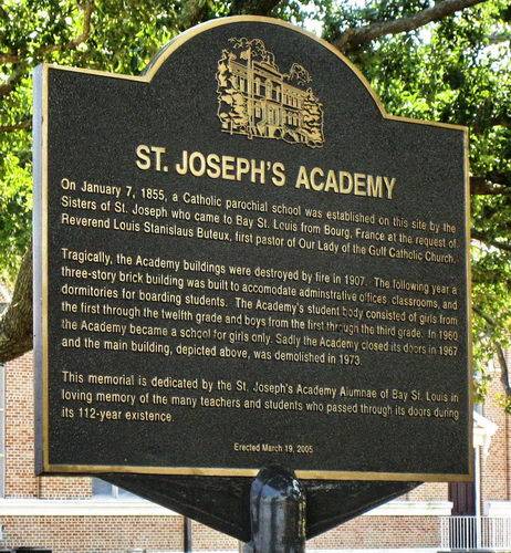
On January 7, 1855, a Catholic parochial school was established on this site by the Sisters of St. Joseph who came to Bay St. Louis from Bourg, France at the request of Reverend Louis Stanislaus Buteux, first pastor of Our Lady of the Gulf Catholic Church.
Tragically, the Academy buildings were destroyed by fire in 1907. The following year a three-story brick building was built to accomodate administrative offices, classrooms, and the first through the twelfth grade and boys from the first through the third grade. In 1960 the Academy became a school for girls only. Sadly the Academy closed its doors in 1967 and the main building, depicted above, was demolished in 1973.
This memorial is dedicated by the St. Joseph’s Academy Alumnae of Bay St. Louis in loving memory of the many teachers and students who passed through its doors during its 112-year existence.
Location: South Beach Boulevard, Bay Saint Louis
Date: March 19, 2005
From The People Of Waveland
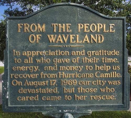
In appreciation and gratitude to all who gave of their time, energy, and money to help us recover from Hurricane Camille. On August 17, 1969 our city was devastated, but those who cared came to her rescue.
Location: 355 Coleman Avenue, Waveland
Date: Unknown
Hurricane Katrina 2005
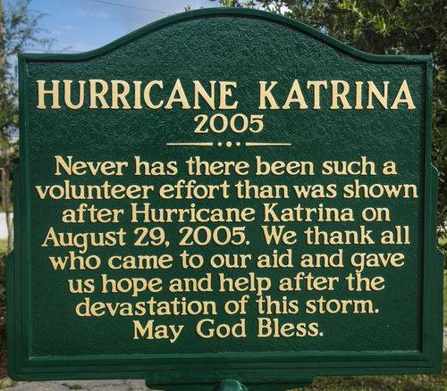
Never has there been such a volunteer effort than was shown after Hurricane Katrina on August 29, 2005. We thank all who came to our aid and gave us hope and help after the devastation of this storm. May God Bless.
Location: 355 Coleman Avenue, Waveland
Date: Unknown