This text was obtained via automated optical character recognition.
It has not been edited and may therefore contain several errors.
ry
national Gateway Since 1837
PARTLY CLOUDY
and warm, with chance of afternoon thundershowers, northwesterly winds gradually diminishing, becoming 10 to 20 miles an hour by late Monday, is the U.S. Weather Bureau forecast. High Monday, 86-90; low, 72-76. High Sunday, 84; low, 75. Weather map, details, Sec. 4, Page 19.
MORNING, AUGUST 18, 1969
Second-Class Postage Paid at New Orleans, La.
SINGLE COPY 10 CENTS
ST OF MISSISSIPPI SHED B Y HURRICANE
ves Toward Mississippi, Alabama
iliiiiiiP 80°
„:if" V :
 ------  .. ...... ■,JACKSONVILLE
PENSACOLA	\
AVCUSTiNTf
---K£Yfk. *
11:00 P.M. SUN.
'85°
1
~	DAYTONA
»•_. V-*:."i •••*»*
8.00 P.M. SUN. j tampa ,
• YSfc
2.00 P.M.SUN.g^g^
\M. SAT.J
A.M. SAT
P.M. ?Rl —	^
*• * * * *'.*.* * 1 T'^' .* ....i__
■HI 8.00 P.M. THURS.
Thousands in Evacuation Shelters; Fringe of Storm Hits N.O.
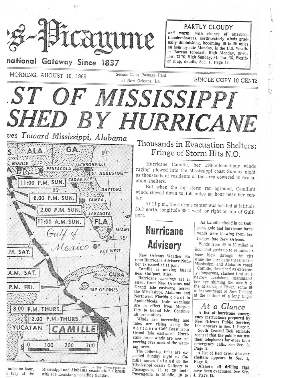
Hurricane Camille, her 190-mile-an-hour winds raging, plowed into the Mississippi coast Sunday night as thousands of residents of the area cowered in evacuation shelters.
But when the big storm ran aground, Camille’s winds slowed down to 150 miles an hour near her center.
At 11 p.m., the storm’s center was located at latitude 30.3 north, longitude 89.1 west, or right on top of Gulfport.
As Camille closed in on Gulfport, gale ajid hurricane force winds were blowing from her fringes into New Orleans. Winds from 40 to 50 miles at hour and gusts up to 70 miles ai hour blew through the citj while the hurricane thrashed th< Mississippi and Alabama coast Camille, described as extreme ly dangerous, slashed first at j narrow Louisiana marshland her eye skirting the mouth oi the Mississippi River, some 9< miles southeast of New Orleam at the bottom of a long fingei
—Mgd by The Tlrrres-Picoyune.
miles an hour,	Mississippi and Alabama coasts after a brush
5 fury at the	with the Louisiana coastline Sunday.
Hurricane
Advisory
New Orleans Weather Bureau Hurricane Advisory Number 18 issued at 11 p.m.
Camille is moving inland near Gulfport, Miss.
Hurricane warnings are in effect from New Orleans and Grand Isle eastward across the Mississippi. Alabama and Northwest Florida coast to Apalachicola. Gale warnings are in effect from Morgan City to Grand Isle. Continue all precautions.
Winds are increasing and tides are rising along the northern Gulf Coast from Grand Isle eastward. Hurricane force winds are now occurring over most of the warning area.
The following tides are expected Sunday night as Camille moves inland on the Mississippi coast: Gulfport to Pascagoula, 15 to 20 feet; Pascagoula to Mobile, 10 to
At a Glance
A list of hurricane emergency instructions prepared by New Orleans Public Service, Inc. appears in Sec. 1, Page 2.
South Central Bell officials request that the public not use their telephones for other than emergency calls. See Sec. 2, Page 2.
A list of Red Cross disaster shelters appears in Sec. 1, Page 8.
Offshore oil drilling rigs have been evacuated. See Sec. 4, Page 19.

Hurricane Camille Camille-Aftermath-Media (028)