
This text was obtained via automated optical character recognition.
It has not been edited and may therefore contain several errors.
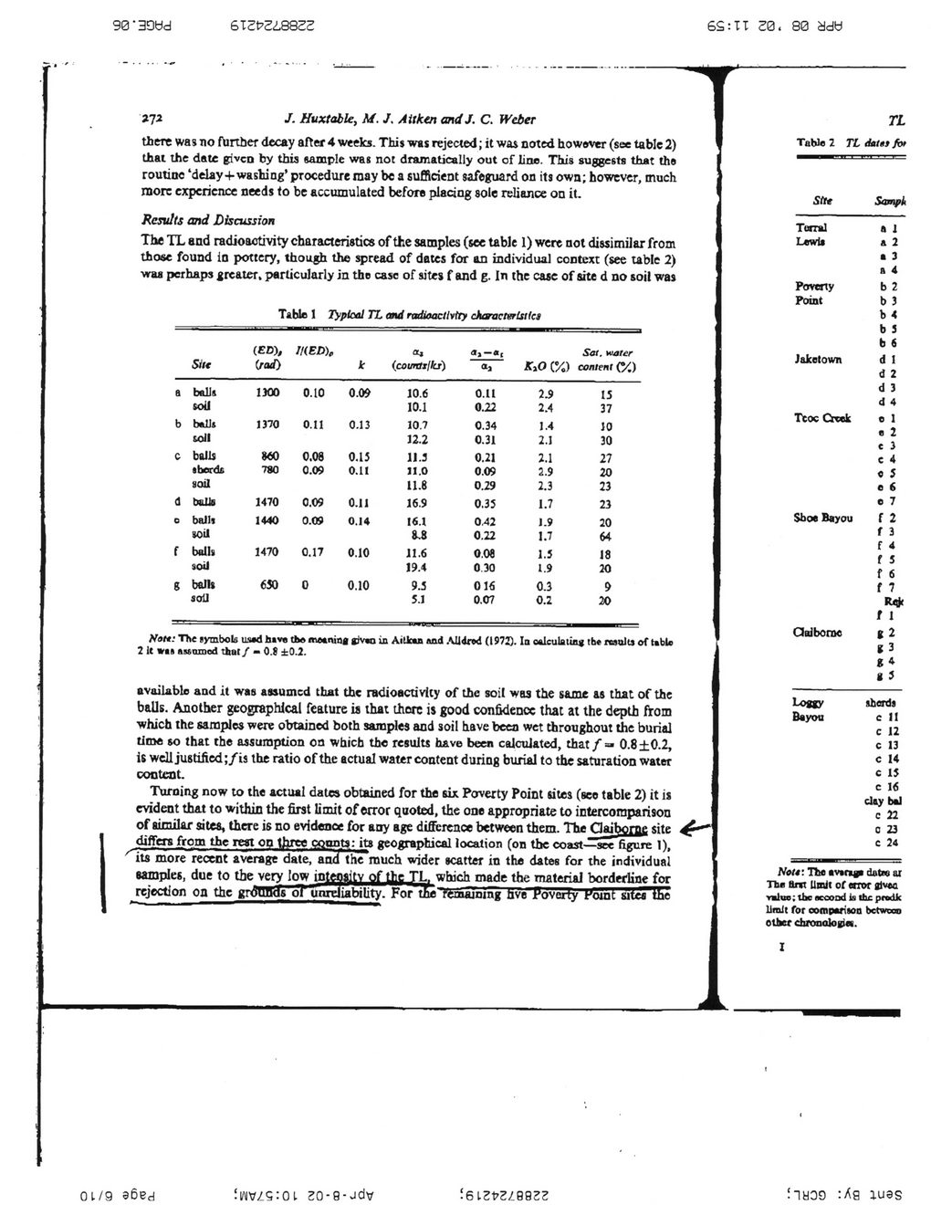
90' 39t)d	6T2t?2i882S
6S:TT
30. 80 add
272
/. Huxtable, M. J, A it ken andJ. C. Weber
there was no further decay after 4 weeks. This was rejected; it was noted howsver (see table 2) that the date given by this sample was not dramatically out of line. This suggests that the routine ‘delay+wasting’ procedure may be a sufficient safeguard on its own; however, much more experience needs to be accumulated before placing sole reliance on it.
Results and Discussion
The TL and radioactivity characteristics of the samples (see table 1) were not dissimilar from those found in pottery, though the spread of dates for an individual context (see table 2) -vraa perhaps greater, particularly in the case of sites f and g. In the ease of site d no soil was
Table 1 Typical TL and radioactivity characteristics
	Silt	11	IKED),	k	(courtiilkr)	<h	K>0 C%)	Sat. water content (?/,)
a	balls	1)00	0.10	0.0*	10.6	o.u	2.9	15
	soil				10.1	0.22	2.4	37
b	b*Ut	1370	0.11	0.13	10.7	0.34	1.4	10
	soil				12.2	0.31	2.1	30
c	bolls	860	0.08	0.15	11.3	0.21	2.1	27
	tberdc	780	0.09	0.11	11.0	0.09		20
	soil				11.6	0.29	2.3	23
d	balls	1470	0.09	0.11	16.9	0.35	1.7	23
0	balli	1440	0.09	0.14	16.1	0.42	1.9	20
	soil				8.8	0.22	1.7	64
f	balls	1470	0.17	0.10	11.6	0.08	1.5	18
	soil				19.4	0 30		20
R	balls	630	0	0.10	9.5	016		9
	soil				5.1	0.07		20
Not*: The symbols us*d have th* meaning jpv*Q in Aitlaa and AUdfod (1972). Ia oalculatiag tht results of table 2 It was auoiDod that/ — 0.9 ±0.2.
available and it was assumed that the radioactivity of the soil was the same as that of the balls. Another geographical feature is that thore is good confident* that at the depth from which the samples were obtained both samples and soil tiave been wet throughout the burial time so that the assumption on which the results have been calculated, chat f =* 0.8 ±0.2, is well justilied;/is the ratio of the actual water content during burial to the saturation water content.
Turning now to the actual dates obtained for the six Poverty Point sites (see table 2) it is evident that to within the first limit of error quoted, the one appropriate to intercomparison of similar sites, there is no evidence for any age difference between them. The Claiborne site differs from the rest on three counts: its geographical location (on the coast—see figure 1), its more recent average date, and the much wider scatter in the dates for the individual samples, due to the very low intensity of the TL. which made the material borderline for rejection on the grounds ol unreliability. For tfce remajoing nve Poverty Koint sites the
TL
Table 2 TL data} for
Site	Sampk
Tonal	a 1
Lewis	a 2 a 3 a 4
Poverty	b 2
Point	b 3 b 4 b 3 b 6
Jaketown	d 1 d 2 d 3 d 4
Teoc Creek	o 1 e 2 c i c 4 o 5 e 6 e 7
Shoe Bayou	f 2 f 3 f 4 f 5 f 6 f 7 R<* t 1
Claiborne	t 2 *	3 *	4 *	5
Loggy	sherds
Bayou	e II
c 12 c 13 c 14 c 1$ c 16 city twl c 22 o 23 e 24
Not*: The mnp datm ar The ant Until of error given value; the acooni is the prodic limit for oompariaon between oilier chronalogin.
I
0 1/9 96ed
fWVZSiOl 20-9-vidv
J6l2t>2/_9922
iiyoo :Ag 1U9S
Claiborne Historical Site Archaeometry-Pp-269-275-(05)