
This text was obtained via automated optical character recognition.
It has not been edited and may therefore contain several errors.
THE OWL, AUGUST 11, 1970
PAGE NINE
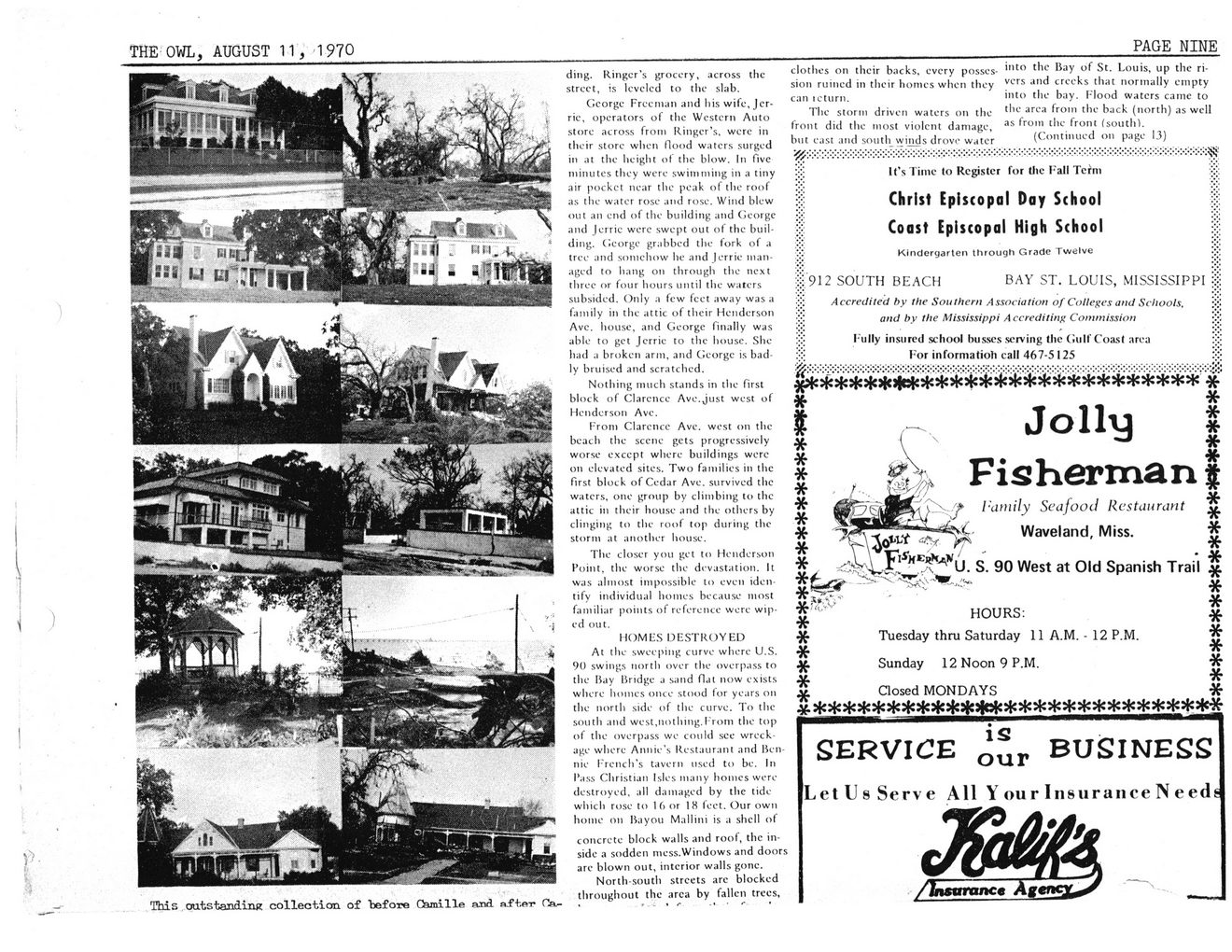
This outstanding collection of "before Camille and af tp-r Ca-
ding. Ringer’s grocery, across the street, is leveled to the slab.
George Freeman and his wife, Jcr-rie, operators of the Western Auto store across from Ringer’s, were in their store when flood waters surged in at the height of the blow. In five minutes they were swimming in a tiny air pockct near the peak of the roof as the water rose and rose. Wind blew out an end of the building and George and Jerrie were swept out of the building. George grabbed the fork of a tree and somehow he and Jerrie managed to hang on through the next three or four hours until the waters subsided. Only a few feet away was a family in the attic of their Henderson Avc. house, and George finally was able to get Jerrie to the house. She had a broken arm, and George is badly bruised and scratched.
Nothing much stands in the first block of Clarence Avc.Just west of Henderson Ave.
From Clarence Ave. west on the beach the scene gets progressively worse except where buildings were on elevated sites. Two families in the first block of Cedar Ave. survived the waters, one group by climbing to the attic in their house and the others by clinging to the roof top during the storm at another house.
The closer you get to Henderson Point, the worse the devastation. It was almost impossible to even identify individual homes because most familiar points of reference were wiped out.
HOMES DESTROYED
At the sweeping curve where U.S. 90 swings north over the overpass to the Bay Bridge a sand flat now exists where homes once stood for years on the north side of the curve. To the south and west,nothing.From the top of the overpass we could see wreckage where Annie’s Restaurant and Bennie French's tavern used to be. In Pass Christian Isles many homes were destroyed, all damaged by the tide which rose to 16 or 18 feet. Our own home on Bayou Mallini is a shell of
concrete block walls and roof, the inside a sodden mess.Windows and doors are blown out, interior walls gone.
North-south streets arc blocked throughout the area by fallen trees,
clothes on their backs, every possession ruined in their homes when they can icturn.
The storm driven waters on the front did the most violent damage, but east and south_ winds drove water
into the Bay of St. Louis, up the rivers and creeks that normally empty into the bay. Flood waters came to the area from the back (north) as well as from the front (south).
(Continued on page 13)
It's Time to Register for Die Fall Tefm
Christ Episcopal Day School Coast Episcopal High School
Kindergarten through Grade Twelve
912 SOUTH BEACH BAY ST. LOUIS, MISSISSIPPI
Accredited by the Southern Association of Colleges and Schools, and by the Mississippi Accrediting Commission
Fully insured school busses serving the Culf Coast area For in forma tioli call 467-5 125
mm
I v Jolly I
| , gS* Fisherman f
If I'umily Seafood Restaurant ^
| Waveland, Miss. *
*^U. S. 90 West at Old Spanish Trail ' *
HOURS: #
■}{• Tuesday thru Saturday 11 A.M. - 12 P.M. ^
■X- *
Sunday 12 Noon 9 P.M. ■X'
V ^
^ Closed MONDAYS *
*Ji* A ^ ^ ^ ^ ^
^ ^ ^ ^ ^ ^ »T* *T* *T* ^ *T* *%* ■’T*
SERVICE BUSINESS
LetUs Serve All Y our Insurance N eeds
rjf*
/Insurance Agi
Hurricane Camille The-Owl-Aug-11-1969 (12)